It was goodbye to
Stuart and Elinor Goldsmith, who caught a taxi back to New Lanark to retrieve
their car and resume their holiday by travelling down to the Lake
District . Then it was au revoir to Susan, who caught a taxi to
Larkhall to go back to Glasgow and thence down
to London
 |
| The bridge back over the Clyde |
So it was back up
the road to the bridge where we had crossed the Clyde
the previous afternoon.
Immediately below
the bridge I came across a fisherman, clearly after salmon. I hadn’t realised
that they run the Clyde, but apparently it’s one of Scotland Blantyre
 |
| The Clyde in spate |
The river was
already quite coloured after the heavy rain over the previous few days, but
still fishable. However, the chap I met was giving up just as we talked. Obviously
today was not to be a lucky one.
Then it was on
down the Clyde valley. Initially it was
pleasant enough, a good path along the river and through woodland, and then a
track just beneath rising ground to the North. Soon the path gave way to a
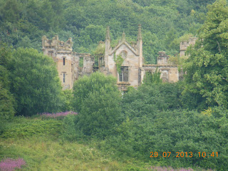
concrete farm track, which passed within a few hundred metres of ruined
Cambusnethan House – a romantic looking derelict building with towers at either
end, peeking out through woods over fields of barley. The track then left the
river, and my way became a rough path through pasture and cattle. This was
genuine countryside, but was overlooked by half a dozen huge tower blocks on
the fringes of Wishaw. This was the beginning of the continuous suburbs to the
Southeast of Glasgow – though they are very effectively screened by trees for
most of the way.
 |
| Cambusnethan House (or is it Priory?) |
The path then
works its way through Barons Haugh nature reserve, apparently managed (at least
in part) by the RSPB, with hides overlooking the lake in the bend of the river.
This starts with an avenue of lime trees, and then a path lined with willow
scrub along the Clyde , mostly hidden from view
behind dense low vegetation. I had already seen quite a lot of Himalayan balsam
along the river opposite Rosebank, but here it was really rampant. It’s an
invasive plant, related to Impatiens, which really loves damp riversides. It’s
become a serious problem in East Anglia ,
and I remember seeing huge drifts of it along the River Eden near Carlisle a
couple of years ago when I walked along Hadrian’s Wall .
It’s not unattractive, but can really overwhelm everything else.
 |
| Clydesdale Country Park amusements |
Although the path
is shown on the map as going right along the fringes of Motherwell, it’s
actually quite well screened from the built up area. It’s actually difficult to
believe you’re passing through a pretty extensive built-up area. But it soon
becomes apparent that you are back in civilisation as you enter the Strathclyde Country Park
 |
| Bothwell parish church |
The final bit
into Bothwell involved navigating a major roundabout at the M74 junction, a
rather overgrown path parallel to as main road, and then a further road
junction. Here this is a memorial to the battle of Bothwell Bridge
The Bothwell Bridge
Rain throughout, occasionally fairly heavy. 14 to
18C. 20.68km; River Clyde Walkway; maximum 66m; 129m ascents, 109m descents.
Mainly grassy track along the river, but paved cycle/walking track in Strathclyde Country Park
No comments:
Post a Comment