Sunday 31 May 2015

Navidale to Berriedale

Rain had been promised; rain duly arrived. Steady, persistent rain, with the cloud base at no more than 200m. So John, Wendy and I were well wrapped up for the ordeal.

Tunnel under the A9 leading to ...
I had studied the map thoroughly before setting off. It appeared that there was a track that went down from a car park a mile and a half along the A9, crossed the burn that cuts a deep cleft in the coast, and then climbed up the other side to finish about 300m from the A9 some way to the east. I had studied the satellite pictures on Google Earth, and thought we could then walk on to a small wood, and on to a further track beyond.

... a promising path, but it petered out after the lookout
It was not to be. We walked down to where we expected to find the footbridge, only to find a small building that looked like some kind of wartime lookout over the sea beneath. Beyond it there was a perilous-looking path with steep slopes down to the sea, and plenty of awkward vegetation to trip the unwary. It was certainly quite inadequate to justify the track symbols that appear both on the 1:25,000 and 1:50,000 OS maps. This wasn’t the only OS map error: several of the spot heights shown on the A9 had not been converted from feet to metres.

However, whatever the map said, for us there was no alternative but to retrace our steps back up to the car park. And with there being no alternative to a wet walk along the A9 John and Wendy not surprisingly decided enough was enough. I can’t say I blamed them. Lunch and the afternoon at Dunrobin Castle would be a much better alternative.

Into the final county - in cloud
For me it was then just a long slog on to Berriedale. There were one or two opportunities for a few minutes’ respite by following the old path of the road before it had been improved, but even then some of those shown on the map proved not to be practicable. So it was two hours of unremitting A9. Anything above 170m or so was shrouded in mist – or more accurately, cloud. And it never stopped raining.

The Berriedale river in full spate
I arrived at Berriedale well before 2:00. Susan had offered to collect me, but I remembered that there was a bus some time after the hour, and besides, there was no phone service. So I couldn’t check the time of the bus. It was just a question of waiting. But at least the rain had stopped.

The bus eventually arrived just after 2:30. I have never been more pleased to see one!


Rain throughout – but clearing after I had finished the day’s walk. 10 to 12C. 14.95 km, 315m of ascents and 340m of descents, including unsuccessful diversion down track. Almost all on A9 apart from fruitless diversion and a few short stretches on the former route of the main road.

Saturday 30 May 2015

Brora to Navidale

Myself, Wendy and John Trueman leaving the
Royal Marine Hotel
The previous day we had said goodbye to Richard and Niki Dale as we put them on the train to Inverness, and welcomed John and Wendy Trueman to the Marine Hotel a few hours later. An excellent dinner, a good night’s sleep, a solid breakfast, and we were ready for the off.

But not without some initial challenges. As John put it, they had not come up prepared for summer in Scotland – no warm clothing (the temperature had fallen below 5C overnight) and inadequate waterproofs (rain promised). Susan wasn’t walking with us, as she had to travel on to Navidale with the car and everyone’s baggage, so she was able to give Wendy her waterproofs. For John it meant buying a pair of waterproof trousers at the golf pro’s shop before setting off. We were served by an American golf professional, who leaves the sweltering conditions of Florida to spend summers in Scotland. Clearly not a snow bird, but I’m not sure how one should categorise his migrations.
Looking back to Brora across the golf course

Then it was off for the start of our walk, across the Brora golf course. This clearly doesn’t have the same sort of reputation as the Royal Dornoch, but it still looks like a lovely links course. But I guess the same is true of a number of Scottish seaside courses.
After the end of the course it was a question of crossing the railway line, and then walking down the A9 for a few hundred yards where there was no other possible way across a couple of streams and the rocky shoreline. Then it was back across the railway line to resume the seaside walk.

Crossing a burn - view from the A9
The next quarter mile or so was rather difficult, as there was hardly any space between the fence and the rocky foreshore a few metres below. And it proved quite unnecessary anyway: the fence was to keep sheep from falling out rather than keeping us out of the field. It would have been far easier just to walk on the other side.

After that it was pretty easy going for a couple of miles to the point where the map showed a path leading back up to the main road. But getting to the path proved impossible: there was a steep bluff covered in scrubby trees, and no obvious way to go up. So there was no alternative but to walk along the railway line itself for a quarter mile or more until we could see as track which would take us back to the road.

A convenient stopping point for lunch
From there on in it was all road walking. Soon after reaching the A9 we had our lunch break in a layby where someone had thoughtfully left a nice clean flatbed trailer to sit on. And then it was the long slog into Helmsdale. There was one stretch where we could get short term relief by going up to a parallel road serving a number of crofts, and a second a mile or two later when we thought we could repeat the trick. But this time the road only went as far as an isolated house. We were told that beyond the house there was a right of way – the old parish road – but that it was now very overgrown. We took it – but after little more than a hundred yards we had to abandon it, and clamber down to a lower level where luckily there was a track down to the A9 from an abandoned house.

The coastal railway line South of Helmsdale
And then it was A9, A9, A9 for the remaining four miles to Helmsdale. The map suggested one possible diversion onto a track that ran parallel to the main road, but there was no obvious way to reach it. And my suggestion that we should divert from the A9 and go through the minor roads in West Helmsdale was vetoed when John and Wendy rebelled at the idea of adding a half mile to the journey – and climbing 60 or 70 metres as well. So it was more dodging traffic for the rest of the way.

The tidal stretch of the,Helmsdale river
The final straw was the fact that we had to climb up out of Helmsdale itself for three quarters of a mile to reach the Navidale House Hotel. Never was the end of a day’s walking so thoroughly welcome.


Bright with some squally showers; still cool. 11 to 15C. 20.75 km, 250m of ascents and 232m of descents. Golf course out of Brora, then a spell along the A9, back to the coast for a while, and then apart from a couple of short diversions on to minor roads, back on to the A9 for the remainder of the way in to Helmsdale and on to Navidale.

Thursday 28 May 2015

Golspie to Brora

This was to be Richard and Niki Dale’s last day with me. It would be a short day, of just a little over six miles, the first of which was through the main part of Golspie itself. The A9 was the broad main street, quite attractive.

So it was a taxi ride back to where we’d finished the day before, now in sunshine. The chap who took us had just started his business – private hire, he described it as, rather than a taxi firm. He had previously had four years on the oil rigs, which he said was quite enough given the endemic level of accidents. So we parted with our £25 and wished him well.

Almost immediately we met a young couple walking towards us. It turned out that they were doing the end-to-end walk starting at the John O’Groats end. We asked whether they had travelled along the coast, but rather ominously they said that they’d had to walk along the A9 all the way from Brora. Apparently they had found it impossible to go along the coast out of Brora. With the tide right in it was all rough shingle and just very difficult going – and they had not attempted to get back to the coast later.

Dunrobin  Castle from them coast
We told them how to avoid the A9 going south, so I hope they managed to follow the path we had taken the previous day in the reverse direction. Our next stop was the Sutherland estates office, which we found quite by chance as we reached the point at which we hoped to join the coastal path. The good news was that it was perfectly practicable to walk between Dunrobin Castle and the sea.

In fact it was a wonderful walk. Open grassland to start, then a path between the walls of the castle’s gardens and the sea, and then a woodland walk         with great drifts of bluebells beneath beech, sycamore and oak trees. And splendid views of the castle itself looking down on us. We planned to visit it later that day, so this was something of a sneak preview.

Looking back at the woods after Dunrobin Castle
After the end of the wood it was more walking across grassy fields before we were obliged for some of the way to walk on the beach. The tide was now on its way out, so whereas the walkers we had met were unable to do so, we now had a much easier time of it.

A geology field trip
This part of the coast, and some of the coast further to the north, has pronounced bluffs between the narrow strip of grass at sea level and the pasture above. In places these become rocky outcrops, and at one of these we came across a large group of young people with hard hats and notebooks. It turned out to be an Aberdeen University geology field trip. We couldn’t work out what they were doing, as most of them seemed just to be standing around and not doing very much. But perhaps they all took turns to study the rock face in more detail. We didn’t hang around to find out.
Waterfalls before Brora

After that it was almost all walking on sand at the water’s edge until we were almost in Brora. The final bit was much harder going – shingle, sometimes quite difficult to walk on. So we had some understanding of why the couple we’d met earlier had elected to take the A9 route. But we were (rather smugly?) self-congratulatory about our A9 avoidance.

The last bit was alongside the harbour and river, across the old bridge (by Telford, no doubt) and to our hotel, the Royal Marine – very comfortable.

We had finished our walk in plenty of time to change and head off to Dunrobin Castle in time for the falconry display, which everyone we’d met had recommended. This was excellent – even if it was rather dampened (literally) by a couple of squally showers. We had demonstrations of the flying skills of a Greenland gyr falcon, a Eurasian eagle owl, and finally a peregrine tiercel. Quite spectacular. The falconer figures in the brochure for the castle as a whole, so he’s obviously almost as much of a pull as the old stones themselves.

Richard and Niki - plus eagle owl
The castle itself was reasonably interesting, but there was no real feeling of the family itself. And a serious amount of historical revision was in evidence. The Highland clearances were not because of the Duke of Sutherland’s desire to replace people with sheep, but because he was encouraging his tenants to go elsewhere to improve their quality of life. But of course! How could one think otherwise?

There’s a huge memorial above the village to the Duke of Sutherland. Apparently locals are split fairly evenly between those that think it should be blown up (memories are long here) and those that think it’s a splendid local sight to be valued.


Bright with squally showers; still cool for the time of year. 10 to 14C. 11.15 km, largely level. 57m of ascents and 40m of descents. Some roadside walking through Golspie, then coastal paths and the beach, largely sand but some shingle. Local roads in Brora itself.

Wednesday 27 May 2015

Dornoch to Golspie

Dramatis Personae: Richard, Niki and me. We planned to catch the 3:17 bus back from Golspie to Dornoch, but Susan was available to pick us up if we weren’t there in time. Our strategy for the day: maximum A9 avoidance.

Is it the 12th or the 14th best golf course in the world?
Different commentators say different things
The start was straight towards the sea, across the golf course. This is the Royal Dornoch Golf Club, apparently voted the fourteenth best in the world. The walk along the paths between the golf courses and the sea was glorious. The golf course itself was immaculate; the gorse everywhere in full bloom; the sea just beginning to retreat from full tide and leave the sands exposed. The golf course occupies a long strip of land between the coast and a bluff, which looks as if it might have been an earlier coastline of dunes. It lasts two thirds of the way to Embo, after which there is a rough track across grassland before reaching the caravan site near the town itself.

This is the largest caravan site I’ve ever encountered – several hundred mobile homes on hard standings, and a number of touring caravans as well. At this time of year only ten percent or so seemed to be occupied (based on the number of cars parked by them), but the whole area was neatly mown ahead of the summer influx.

Some of the newer houses in Embo
Embo itself is a small village, perfectly rectangular in layout, with parallel rows of small cottages at right angles to the coast. It was originally a fishing village, although there’s no harbour, so boats must have been hauled across the shingle and sand to get to the sea. That’s all long gone: nowadays it’s largely holiday cottages, although a few seemed to have year-round residents.

After Embo it was along, sweeping path to the Southern shore of Loch Fleet. There were big dunes covered in silvery grass on the shoreline, and then an area of clear felled wood with pools of water among the whitening stumps. 

More gorse along the old railway line
On the later stages of this walk it became obvious that this was a disused railway line, though there was no obvious evidence that it went on to Embo or Dornoch. This was easy going, with plenty of wildlife: herons flying off as we approached; ducklings with their mother in a pool beneath willow trees; a couple of deer fleeing from us.

Clear fell area before Loch Fleet
The lie of the land is such that it’s only a mile or so before you reach it that Loch Fleet comes into view. We found it with the tide almost at full ebb. There were sandbanks exposed in the middle of the Loch, and large areas of exposed bladderwrack and other seaweed nearer the shore. Here the wildlife was seals on the sandbanks, oystercatchers probing the seaweed, and groups of mainly drake eiders on the water. Plus plenty of seagulls, of course. It made for a wonderful sight as we stopped briefly for refreshments.

After this it was a couple of miles or so along the minor road on the south shore of Loch Fleet: very picturesque as we approached the A9. We would have to go along this to cross the bridge at the head of the Loch, but I was keen to avoid joining it any earlier than absolutely necessary. So it was down onto the sand instead.

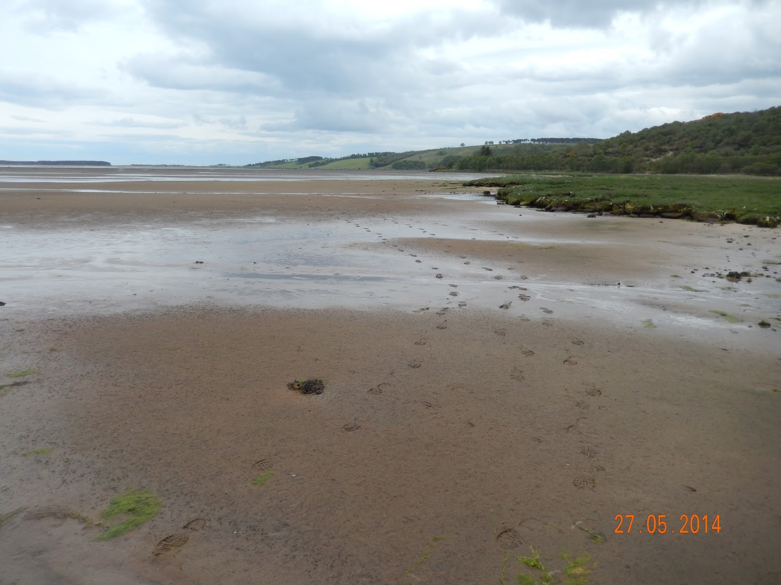
The top end of Loch Fleet at low tide -
with our footprints showing our route across the sands
This proved a much better option. We had been apprehensive about it being soft or muddy, but there was evidence that some kind of tracked vehicle had been on it not more than a few days ago. It proved easy going, and there was evidence of previous walkers – not humans, but deer and otter footprints. The last stretch was along the sand below the causeway that leads to the bridge itself. This was covered in gorse and other vegetation. And it’s obviously ideal eider duck nesting habitat: we put up a dozen or so eider females that came rocketing out as we approached. It seemed rather inappropriate behaviour. It would have been much better for them just to sit tight and not alert us to their nests.

After clambering up to the level of the road we had less than 100m to go to the bridge, and after crossing it and walking a further 400m along the A9 or so we followed a man who had parked on the opposite side of the road and taken a footpath in to the woods on our right. So we had managed to restrict our A9 walking to little more than half a kilometre. Richard had read someone’s blog saying that it was impossible to avoid walking along the A9 on the stretch between Golspie and Dornoch, so we felt rather superior.

Creag Bheag - a bouldering site on Loch Fleet
The path was a pleasant woodland interlude. And eventually we found the chap we had followed at the foot of a cliff, which according to the map is called Creag Bheag. He said he was bouldering – rock climbing without ropes or harnesses. Not my idea of fun, particularly if you are all by your own and miles from anywhere. But I can report is that his car was no longer where he had parked it when we drove back past later in the day, so presumably he had survived.

At any rate, he confirmed our position, and told us that we were essentially on the right track, so we resumed our walk with renewed confidence. We found a place where we could cross the railway line relatively easily, and where there was a conveniently placed bridge across the burn on the other side. 

Balblair Wood and Loch Fleet
Then we saw a footpath marker at the edge of the main part of Balblair Wood, which occupies more than half of the area between Loch Fleet and the A9. A quick check of the compass (the first time I had used it this year!) to see that we were walking in the right direction, and then two miles or so through the wood. This is all scots pine, at various stages of maturity, and easy going on forest tracks. It’s all part of the National Nature Reserve, and there are areas which have been quite recently fenced off to protect something or other. The chicken wire extends only a couple of feet above ground level so it’s difficult to imagine what is being kept out – or in. Presumably not foxes or rabbits. Research required! At the end of the forest stretch there were notices telling us more about the wood – Scottish crossbills mentioned, but no explanation of the fencing we’d seen.

A chainsawed welcome to Golspie
We now had a final mile and a half on a minor road in to Golspie. It began to rain. We had been lucky thus far, as showers had been suggested, but this was the real thing, and it got progressively heavier as we walked along the pavement beside the road and golf course.
It was a good half hour too late for the bus, so I called Susan to request a lift. Richard (whose anorak is reaching the end of its waterproof days) and Niki managed to find shelter in the local community centre, but I had to stay out of doors to make sure Sue knew where to stop. And by the time she arrived it was really pelting down.

It had been an excellent day’s walk, even if a little too long, so that we were flagging by the end, and if it had been a little shorter we wouldn’t have got the soaking. But there had been plenty of variety, great scenery, and a certain amount of unanticipated adventure. And not too much of the A9!


Cloudy, getting slightly warmer. Rain mid-afternoon, becoming heavy as we reached our destination 11 to 16C. 23.85 km, largely level. 83m of ascents and 85m of descents. Track across golf course; grassy path; tarmac through campsite and Embo; then more grassy paths, followed by old railway line. Minor road along S shore of Loch Fleet; across sand (low tide) to A9 just before bridge; A9 across bridge and for a further 500m, then path through woods down to N shore of Loch Fleet. Into pine woods with forest tracks, and final mile and a half on minor road.

Tuesday 26 May 2015

Tain to Dornoch

We had spent much of the previous day – notionally a rest day – taking John Poulter to Inverness Airport, hanging around there, and collecting Richard and Niki Dale from their easyJet flight. On the way back to Tain we showed them the dolphins at Chanonry point (an excellent display, with many salmon consumed) and some of the Black Isle.

Myself, Niki and Richard Dale - ready for the off
from the Carnegie Lodge Hotel
This was the first of the three days Richard and Niki were to accompany me. It was not a promising start: the forecast was for showers and generally low temperatures. It wasn’t actually raining as we started, but it certainly felt as if it might soon.

The initial stretch was down the minor road that runs past the hotel, and then a short length of the A9 as it bypasses Tain itself. The previous day I had noticed a sign pointing towards the Pictish Way, which seemed actually to indicate the beginnings of a path. But the Pictish Way is actually a tour of various Pictish stones, not a walking trail, and what had seemed the beginnings of a trail was in fact a defunct bit if old road. So we had to retrace our steps. 

The next approach to A9 avoidance was to see whether we could get down to the shoreline of the Dornoch Firth. This too proved fruitless: no way to cross the railway, and some new structure jutting out into the Firth from the Glenmorangie distillery half a mile to the West.

The omnipresent A9 before crossing Dornoch Firth
So the A9 it had to be, at least for a while. But there was a minor road off it to the South, and the map seemed to show a series of connecting tracks that should get us back to the A9 just before the Dornoch Firth bridge. And so it proved. Getting away from the A9 was a great relief: it wasn’t as busy as it had been the previous day with bank holiday traffic, but it was still a daunting prospect to walk along it for any length of time. Even worse, you can hardly hear one another over the noise of the traffic.

Our alternative took us past a few scattered houses, then what increasingly appeared to be the driveway of a large house. This proved to be the case – Tarlogie House, according to the map, with well-maintained lawns. Just as we had that sinking feeling that we’d have to retrace our steps and find some other way through we were lucky enough to find a well-established footpath, not marked on the map, but going exactly where we needed. After that it was an easy gravel road down to the roundabout where the A9 turns North to cross the Dornoch Firth.

The worst is over: looking back at
the Dornoch Firth bridge on the A9
This was the truly horrible part of the walk. The road doesn’t have any proper footpath, just a white line a yard or so from the edge which is supposed to indicate a cycle track, and then a couple of feet of granite chippings on the causeway before the bridge, which becomes a narrow raised pavement where the bridge itself starts. The traffic is approaching at 50 mph or more, and anything larger than a car produces a real shock wave of air. And just as we started the 1 km or so of the bridge itself the rain started – driven rain on half a gale of wind. The only minor redeeming feature was that we were on the East side of the bridge, facing oncoming traffic, and the wind was from the West – i.e. from across the road, blowing us against the railings, rather than the other way around.

Reaching the other side was a huge relief. We were able to clamber down the steep bank at the end of the causeway on the North side of the bridge, and follow a track for parallel to the road until we reached the minor back road in to Dornoch. This was through the burnt skeletons of old gorse with new growth beneath in vivid flower, and areas of heather. Just before the road itself there were plantings of new broadleaf trees as well. And just as a final reward the rain and wind abated. It was almost as if their earlier intensity had been a test.

The bank along the minor road into Dornoch
The last bit was a straight walk of about 5 km in to the centre of Dornoch. All very level, just a foot or two above the level of the sands in the Firth, and really rather attractive. Banks of gorse; lots of bluebells; larch and pine woods; horses and sheep, some with and some without their (mint sauced?) lambs; occasional houses; a series of fishing lakes; a driving range. The banks on the inland side of the road were extensive, an about 6 or 7 metres high. They looked man-made, but I can’t imagine why anyone would want to build them. They were hardly continuous enough to be sea defences, and in places seemed to head off inland. Very strange.

Dornoch Castle
We were slightly delayed by Richard and Niki having to tackle issues at home: a painter turning up at their temporary home a week before the appointed time. I think it slightly spoiled their day to have to make a number of phone calls instead of enjoying the last bit of the walk.

We arrived at the Castle Hotel before 1:30, so it was a late lunch before R&R in the afternoon.


Cloudy, cold, with occasional rain and even more occasional brief glimpses of blue sky and sunshine. 9 to 14C. 14.14 km, largely level – only 55 m of ascents and 112 m of descents. Some on A9 verges, some on tracks, but mostly on minor roads.

Sunday 24 May 2015

Kildary to Tain

Stuart and Elinor had eaten with us the previous evening, but had stayed at the Royal Hotel in central Tain, as the Carnegie Lodge was fully booked with cyclists on their way to John O’Groats. In any case, the previous day had been their last, so only John and Susan were available to accompany me. Susan had a blister in the ball of one foot and an inexplicable black big toe on the other, so it was just down to John and myself.

The view down over the Firth of Cromarty
This was to be a short day, since we could start from the point in Scotsburn (or was it Marybank?) where we’d turned off for Kildary the day before. So it was a simple matter of getting Susan to take us back up the road from Tain, after which we would just go back down the same route. All rather silly, it seems in retrospect, but my objective is, after all, to walk the whole way from Land’s End to John O’Groats.

The road from Scotsburn to Tain starts by passing a series of detached houses in an area, according to the map, called Lamington. These are nearly all fairly new and large, with expensive cars parked in their driveways. Lots of horses, too. So presumably they’re largely residents’ houses rather than holiday homes. It’s difficult to understand why this area is so apparently affluent. 

A smartly dressed local resident.
Perhaps it was the offshore oil industry that brought wealth to the area: if so, they must be suffering now given the recent downturn of the North Sea now that the fields are depleted and the price of oil has collapsed. I’d thought that it was Aberdeen that got the lion’s share of the wealth generated by the industry, but it must be more widespread. Nigg, after all, has a lot of offshore related industry, and so too must Invergordon, and there are half a dozen or more oil rigs moored in the Firth of Cromarty.

After this it was a stretch through woodland, where we were offered the alternative of paths to the North. We could have taken them had we wanted to extend the walk, but our preference was to get back early and do some local exploring for the rest of the day.

The wooded part of the walk back to Tain 
The final stretch into the outskirts of Tain were through farmland and then a number of houses far less grand than those we’d passed in Lamington. And then it was through the housing estate outside the A9 bypass, and back to our hotel only a little after 11:00. There were a few spots of rain as we approached the A9, but otherwise it was largely a bright and pleasant morning’s walk. And the time passed even more rapidly given the excellent company provided by John Poulter.

With the walk taking only half a day there was time to go in to Dornoch to see the cathedral and have lunch, and then to explore the coast as far North as Brora. Which was just as well, as it gave us an opportunity to see the Sutherland Inn in Brora, which is right on the main road. Further research suggested that this had declined to a dramatic extent, so we were able to cancel our booking and get in to what seems like a much more satisfactory alternative.

We shall see!


Bright, but with a fair amount of cloud, and occasional few shower. 12 to 15C. 7.51 km, largely level – only 41 m of ascents and 68 m of descents. All on minor roads.

Saturday 23 May 2015

Dingwall to Alness

Yesterday was change-over day: Rosemary and Alan away to the South, and John Poulter, and Stuart and Elinor Goldsmith, arriving on the flight from Gatwick to Inverness.

Dolphin watching
Actually that’s rather over-simplifying things. In the morning Susan and I went to Chanonry Point to watch the dolphins, and were there with Rosemary and Alan (and 100 or so others) to witness a tremendous display of ten or more dolphins, including a mother and calf performing synchronised rolls not more than 20 meters from the shoreline. Then we managed lunch together in Cromarty before we had to head back to the hotel in Muir of Ord to greet our new walking companions.

We came across John half way along the drive to the hotel. His taxi had delivered him to the wrong hotel, and he’d already walked most of the mile and a quarter between the two hotels before we were able to rescue him with a lift for the final few yards. He had missed Stuart and Elinor at the airport, and they had been forced to wait for a hire car to arrive on a transporter before setting off to meet us. However, all were duly assembled, and after a brief walk around the block and an excellent dinner we were all set for the walk on the following day.

So in the morning it was an early breakfast, and then off to catch the 9:16 train to Dingwall. This was over-heated, but it was only ten minutes to take us to the point where I had finished the previous section with Rosemary and Alan Towers a couple of days earlier.
More gorse

So it was back up the High Street (a little more lively than when Susan and I had been there two days earlier, but still showing the negative impact of the huge Tesco on local businesses), and then up a hill to get to the minor road that runs parallel to the main road to the Northeast. The town continues for some way along this road, with the houses getting obviously newer as one gets towards the countryside.

After this it was actually quite a pleasant walk: even though it was all on the road, there was little traffic, so we were all able to walk side by side in groups of two or three for most of the time. The first part was gently uphill, but then there was a relatively level stretch before dropping back down again. It was very pleasant to have a larger group than usual. One can change ones walking companion form time to time, and get to spend time with everyone else.

Oil rigs on the Firth of Cromarty
And the views were great. 100 meters above sea level provided enough elevation to have wonderful vistas over Cromarty Firth, changing with the state of the tide, and across to the Black Isle, with its patchwork of fields, several of rape still in fine yellow flower. To the Northeast there was a series of oil rigs moored in a precise line between Nigg Ferry and Invergordon.

An easier alternative?
About half way to Evanton we came across a group of cyclists having a rest break, with their support van in attendance. This was emblazoned with pictures and advertising, including mention of the Land’s End to John O’Groats challenge. That was what this group were doing – and they were on the penultimate day of fourteen. It meant that they had to cycle 60 or 70 miles a day. I thought that this must make anyone saddle-sore, which was rather borne out when I saw one of them standing on the pedals when freewheeling downhill.

Stuart knew this part of the world quite well, as until seven or eight years ago he had owned a chunk of forestry in Glenglass. He assured us that there were a couple of pubs in Evanton, though I was suspicious, given that there was no blue tankard on the map. But he was right, so after not more than a few seconds’ hesitation we went in for a break – and drinks all round. This was a welcome break. Though the weather forecast had promised improving conditions as the morning progressed, the reverse proved the case, and it had become quite chilly and was beginning to spit with rain as we approached Evanton.

The easier way back to Muir of Ord
This was also the point at which Elinor and Susan finished their day’s walking, and caught a bus back to Dingwall. For Stuart, John and myself it was back to the road (rain finished), sandwiches in a bus shelter (better than sitting on someone’s garden wall) and the final three or four miles to Alness. Initially this was on a high quality cycling track that parallels the road and runs through pleasant woodland, but the last mile into Alness itself was along a dead straight road with no redeeming features and plenty of traffic. The only consolation was that there was still a cycle track, even if it was more like an ordinary pavement.

Then we were in luck: the timing proved perfect to catch a bus back to Alness, from which we could catch a connecting service back to Muir of Ord. So we were through the day’s walk and comfortably back in the hotel by mid afternoon.


Initially bright, but becoming more cloudy as the morning progressed, and a little light rain at lunchtime. Brightening in the afternoon, and sunny as we finished the day’s walk. 12 to 16C. 17.95 km, 150 m of ascents and 136 m of descents. Minor roads for most of the journey, though a little of the final stretch was on a walking/cycle track that runs parallel with the road.


Friday 22 May 2015

Alness to Kildary

The walking party, 23 May, at Ord House Hotel
Tom, Susan, Elinor, John and Stuart
This was a moving day, so it was time to pay our bill (how did they manage to make mine exactly £999.90?) at the Ord House Hotel, and move on to Tain. Susan and Elinor drove the cars, dropping Stuart, John and myself off exactly where we had finished the previous day, before driving on to Tain. The plan was for them to join us for lunch and then finish the day’s walk at Kildary.

So we set off in fine weather, first of all to walk for a mile or more through Alness itself. The town has a grand, wide main street, and a few large 19th Century houses in the centre. But most of the fringe of the town is much newer, and we
Alness - a handsome centre
finished up the urban part of the walk going through an estate under development, with a dozen or so rather ugly “executive homes” at various stages of completion. It’s all rather surprising. Scotland’s population is not, as far as we know, on the increase, and peak oil is history, so why is so much housing in these towns so new? Research required.


At last we were out of Alness itself, and on the minor road to Mossfield. This was the start of what I had planned to be one of the two off-road parts of the day’s walk (although in the event it was the only one). It started with a grassy track between two houses, a kissing gate made of plyboard with scarcely room to squeeze through, and then a few hundred metres of muddy track through woodland. It meant rougher going, which we all found a little more tiring than road walking, but it was certainly more enjoyable.


A continuous roll of silage. How do they do this?
Then it was open fields, inspected by a series cows – firstly a field of yearlings, then by one of heifers and their first calves. The final bit was along a track leading to what must have been a haulage contractor’s business, with abandoned trailers in the field and along the lane. I never cease to be amazed by the amount of junk that gets left in so many farms. Farmers may expect walkers to observe the country code, but they seem to ignore it themselves. 

The next stage was a long, steady uphill haul - just the sort of gradient that seems easy but actually takes some effort. To our left was a field of rape in full bloom, now stinking with overtones of cabbage; to our right there was what is obviously a major riding establishment, complete with a covered manège and extensive stabling. There were also several holiday cottages, which underlined the fact that this is a major operation. As Stuart and John commented, it’s probably more profitable than farming. And shortly afterwards we came across an area where flags were flying around a paddock, and a field was being marked out for parking. Presumably some major horsy event was due to take place over the bank holiday weekend, thought there was no signage explaining what it was to be.

The hope that we would meet up with Elinor and Susan by noon had obviously been wildly optimistic. It was already close to 12:00 and we still had more than two miles to go.  Frequent exchanges of phone calls kept putting the time back. But at least it wasn’t only my optimistic assessment of how long it would take: Elinor and Susan had been dropped by their taxi well short of the intended meeting place, so had to walk more than a mile themselves.


Bog cotton
Our final bit was something of a route march, mainly along what the map showed as woodland, called Badachonacher Moss. What OS maps fail to show, of course, is the maturity or otherwise if woods, and it turned out that much of this one was clear felled. My original plan had been to take forest tracks through it, but that was no longer sensible. It would have added another half mile or more to the journey, and besides it wasn’t woodland any more.

Although the trees had all gone, leaving large areas of moonscape, they had left a few trees at the roadside, and the felled area had the most extensive and dense growths of bog cotton I have ever seen. I remember lots of bog cotton from the Pennine Way a couple of years ago, but this was much more remarkable.

We actually managed to walk past the point where Elinor and Susan had found a picnic table, and they had to call us back. It was now much chillier, so our lunch didn’t detain us long. Then it was the final stretch, downhill pretty well all the way to Kildary.


The most intense gorse yet
Gorse had been widespread before, including extensive borders along roadsides and forest edges, between fields, and even large areas of hillside. But the road down to Kildary and the journey on to Tain was of a different intensity altogether. Here the gorse was at its flowering peak, with the blooms so dense that bushes seemed entirely yellow. This must be one of the most gorse-intense areas in all of Scotland – though there is certainly no shortage elsewhere.

We called for the taxi that had taken Susan and Elinor up to meet us, and it collected us from Kildary after no more than a few minutes wait. So we arrived at our next hotel, the Carnegie Lodge in Tain, by early afternoon.


Bright, but with a fair amount of cloud, and occasionally chilly in the wind. Better later in the day. 14 to 18C. 18.55 km, 260 m of ascents and 232 m of descents. Minor roads for most of the journey, apart from one two-mile section through woodland and fields.

Wednesday 20 May 2015

Muir of Ord to Dingwall

This was to be the last of the three days with Alan and Rosemary Towers. They would be going back down South for the weekend, but returning to accompany me for the final two days early next month to John O’Groats itself.

Rosemary and Alan on the Black Isle
As the crow flies – and by way of the main road – this is only about 9km. But the direct route didn’t appeal, so we manufactured a route by way of minor roads to the East of the main road, and then crossing the river on the main road (there is no alternative) and a final stretch of a mile or so into Dingwall itself.

Muir of Ord has a splendid name, but not a splendid nature: it’s actually a rather plain little town. A few older houses in the centre; an industrial estate with huge buildings on the road from Beauly; lots of newer estates on the fringes; and major new building projects offering new 2 or 3 bedroom houses at “from £100,000”, or at £365 per month with Help to Buy support. It still seems incredible that for the price of our flat in London we could buy ten houses up here. Such is the law of supply and demand.

It’s not even as if this is a particularly impoverished part of the world. Indeed, it seems quite prosperous. There are a lot of relatively new homes in the area, many very substantial, and plenty if other signs of prosperity. Of course, it’s pretty close to Inverness, so presumably a large proportion of the local population commutes in to town. But I shall leave this as conjecture: I don’t plan to study local traffic movements early in the morning.

The rabbit warren between two fences
Our route took us on minor roads through areas called Balvaird and Newmore. You can’t call them villages: they have no focus, and simply comprise 30 or 40 separate dwellings, each with a house name and a number – 19 Balvaird, for example. Once again each seemed to have a smallholding of 10 acres or so. All are pasture, most with a few sheep, and several horses. The sheep included a pair of totally coal-black animals with white flashes on their faces – something I’d never seen before.

The route involved regular right angle turns, and in an attempt to avoid walking three sides of a square on one occasion we tried to find a track where none existed. Two parallel lines on the map, the distance apart that would appear to indicate a track, represented what were in reality fences – and the area between was a continuous rabbit warren. I was prepared to cross the barbed wire, but Rosemary and Alan declined, so there was some inevitable retracing of steps.

Descending back to river level
Our progress was watched over by a pair of red kites. We saw them frequently, and initially thought there must have been more than two, but we never saw more than the two at one time, so presumably they were just quite wide-ranging. I hadn’t realised there were red kites up here: Galloway, of course, but not here. Were they evidence of another scheme in this part of Scotland, or wanderers from elsewhere?

After few kilometres on the heights of the Black Isle we came across a sign post pointing to Conon Bridge. Some careful map reading suggested that we could take this route, and after half or mile or so on the main road would be able to walk down to the river and along its bank to the bridge. And so it proved: a delightful riverside walk, mostly through woods that flank the river, and finally across a little open ground in to the town itself.

The River \Conon in flood
The Conon was in boisterous mood, flowing powerfully and probably two or three feet above tis normal level. But it’s surprisingly clean with such a big flow – clear, with no sign of the discolouration that happens with so many rivers in spate. No wonder the fishing in these rivers is so highly rated. Though perhaps not by the two fishermen we saw just below the bridge: the water, one said, was too big, and besides this part of the river would be at the top of the tide in just a short while.

The final part of the walk was through the town of Maryburgh and along the road into Dingwall itself. Fortunately there was a cycle track parallel to the (busy) main road, so we weren’t as exposed as I’d feared over this last stretch. But Rosemary and Alan put on their long league boots, and I found myself a hundred metres or more behind them before they noticed and waited for me.

The rail bridge over the Conon in Maryburgh
Then there was time for a quick coffee at the station tea room before catching the train back to Muir of Ord. As a final treat Susan was able to meet us there so that we didn’t have to walk the final mile back to the hotel.


Bright for most of the day, but with cloud building progressively. Much warmer than recently – 11 to 16C. 12.66 km, 221 m of ascents and 266 m of descents. Minor roads to start, then riverside path, and final 3km along A862.