Wednesday, 13 June 2012

Hay-on-Wye to Kington

Two rest days with (brother) Nick and (sister-in-law) Moira in their immaculate house in Hay. Or almost immaculate: there’s still one room filled with the various stuff they’ve accumulated over the years but for which they still have to find homes. Their house is beautifully renovated, with lots of original wood complemented by well-chosen new bath and kitchen appliances, and with great pictures everywhere – many by my mother, who was a very talented artist.

One had to be careful, though: slippers mandatory when indoors, and an accurate description of what they do when going upstairs or downstairs on polished old wooden steps, some of which are rather uneven or slope towards the front. I hope they’re well-insured for their B&B guests. Though no casualties were reported for the ten days during which they had put up Hay Festival speakers. It had obviously been demanding and stressful, which was evident in Moira’s reaction to my muddy (but dry!) boots and trousers when I first appeared on their doorstep.

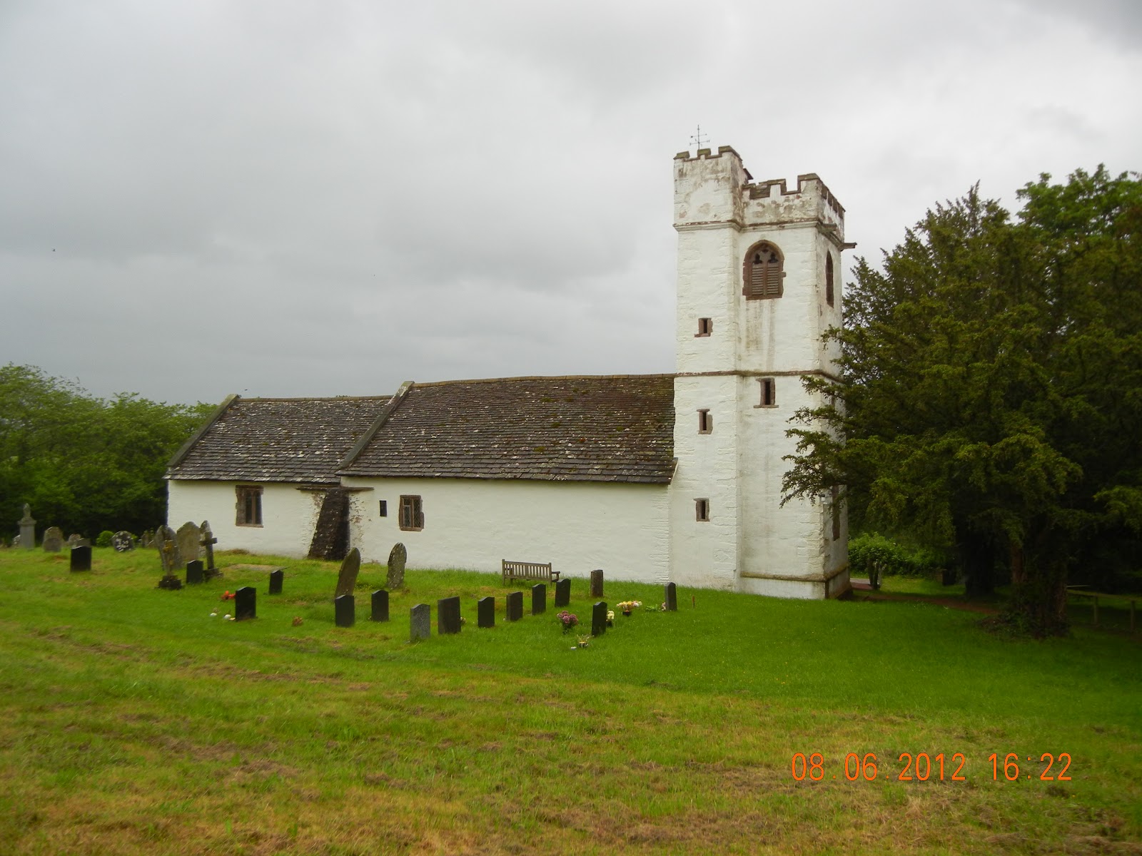
The East door of the church of St Mary
and St Nicholas with its unique carvings
We were joined by Susan, arriving from Hereford by bus that evening. Monday was dinner in; Monday a local walk in a loop to the South of Hay followed by dinner out at the Griffin in Felin Fach some dozen miles away (very good), and Tuesday was a guided tour of three churches on our way to drop Susan off in Hereford for her train back to London. First there was Dore Abbey, a grand church which is the only remnant of a major Cistercian monastery; then St Nicholas’s Church at Grosmont (partly an ancient nave, but with much of the body of the church rebuilt in Victorian times), and then the tiny Norman church of St Mary and St David, with extraordinary, unique and well-preserved carvings around the door and beneath the eaves. Nick is obviously a great enthusiast of church architecture, and there are plenty of interesting ones in this part of the country.

On Wednesday it was time to set out again and resume the Offa’s Dyke Walk. Nick and Moira elected to accompany me, at least for some of the way (which turned out to be all but the final bit into Kington).

This is more domestic country than the Black Mountains to the South of Hay. There are open fields, largely arable, on the flood plain alongside the Wye. And there was even someone fishing in the river itself. It made me feel rather nostalgic about times I had been salmon fishing on the Wye, but I’m not sure it would have the same appeal if one can’t keep anything one catches.

After the first couple of miles it was a turn to the left and up into the hills. It’s undulating country, attractive, almost entirely sheep farming, though with occasional cattle. Views from the higher levels are superb, and it’s an entertaining challenge to work out which distant hill is which.

Lunch at Newchurch with Nick and Moira
Just before reaching it we came across a couple struggling up the hill from Newchurch. She was heavily loaded, and thrust a leaflet into our hands. She was on her way from John O’Groats to Land’s End – but was “walking for Jesus” rather than purely for exercise. Late 60s? She had started the previous year, but was forced to stop because of injury; she had resumed in Penrith at the beginning of May, and planned to get to Bristol on this leg.

At Newchurch we found that the church provided drinks and biscuits on a serve-yourself basis, and there was a table outside for lunch. Very welcome – and an excellent way to get the extra few quid for church funds. I’m surprised that it isn’t a more frequent offering: there are, after all, enough churches on the way across country.

After Newchurch it’s a long climb up Dysgwilfa Hill – open moorland at the top. Then there’s a long, high level traverse before the descent into Gladestry. Very attractive country. At Gladestry it was time to say goodbye to Nick and Moira, who were to catch a taxi back to Hay (There’s only one bus a week from Gladestry, and that’s on a Tuesday, and doesn’t go to Hay.)

Monkey Puzzle trees on Hergest Ridge - an incongruous sight
Then it was the final cross-country stretch into Kington. This is across Hergest Ridge – a wonderful open area, with a maximum altitude of just over 400m, and superb views in all directions. Now one can see the hills to the North and West as well as across lower levels to the East. It’s smooth grass paths between large expanses of still quite young bracken. Here, apparently, it’s mown and baled for animal bedding. At the top of the Ridge there’s an incongruous copse of monkey puzzle trees, and the tracks of what used to be a race course. And then it’s the long final descent into Kington.

I arrived at Church House at 5:30; Liz Darwin showed me my room, made me a cup of tea, and dashed off, leaving me to wait for Irvine Laidlaw. It was a fine evening, and their garden is gorgeous. Just a pity that the splendid wisteria was past its prime. A few late flowers, but nothing like the display there must have been a monh or so ago. The house is beautiful, too – Georgian, and well proportioned, with a warm, comfortable and lived-in feeling to it.

The view North from Hergest Ridge, just before Kington
Irvine turned up bang on schedule at 6:30, and as soon as I had finished my delayed bath we set off for the Stagg at Titley in the BMW Alpina Z8 that he had just imported from the US (one of a limited edition of 555 cars, apparently). There we had an excellent dinner, though the service could be somewhat abrupt, with plates whisked away almost before you had put down a knife and fork.

On our return Ollie, Liz’s son, was in the garage with a couple of his local buddies, playing around with motor bikes. Ollie is at UWE in Bristol, doing a business degree, but is already in business selling motor bike parts around the world. Evidence, if one ever needed it, of the way that the Internet makes all sorts of new enterprises possible.

Ollie and his friends – and Irvine – were in seventh heaven talking about cars, bikes, engines, and the like. All over my head, I fear.  But it did become rapidly apparent to all that Irvine is rather wealthy and well-endowed with classic cars. And so to bed.

An excellent day, despite the forecast. Almost totally blue sky to start with, and then cloud building up during the day. Looked threatening in the early afternoon, but then improved to finish with a sunny evening. Despite the threats, there was no rain. Temperature 15 to 21C. 26.23km; 724m ascent, 629m descent. Moderate to severe. Very undulating with four major climbs.

Sunday, 10 June 2012

Llanthony to Hay-on-Wye

My guess was that everyone at breakfast was a walker, but in fact I never saw any of them again, so perhaps some were cyclists, or at least going eh other way. I left soon after 9:00, having arranged for my luggage to be taken on to brother Nick’s home in Hay.

The local horses taking it easy
There were no more than a couple of hundred metres of gentle going before the path turns uphill, and then its solidly uphill for 2km or more. It rapidly became apparent that the route I had taken down the previous afternoon was the wrong one, and obviously less well defined and more difficult. The route I took this time was much easier to follow. It may not appear as a nice green dotted line on the map, but it’s pretty obvious on the ground.

It’s a long ascent through – the best part of 400m of climbing from the Half Moon and Llanthony Priory. Most is relatively modest in gradient terms, but there are several steeper pitches. Quite soon after leaving the priory I was passed by a group of three climbers (out for a day trip from Bristol, it later transpired), but felt rather better when I found them taking a rest near t he top of the climb. Classic hare and tortoise stuff!

Looking back down at Llanthony Priory
After that it was just a long fairly level walk across the top of the ridge. This is right on the boundary between England and Wales, and involves an almost imperceptible climb from an initial 600m where one first reaches the ODP to just ov er 700m where it reaches its highest point some 5km later. There are good views to the hills in all directions, but the lie of the land is such that you don’t really see down into the valleys. I had been told before starting on this section that I might find it more interesting to get to Hay via opne of the valleys either side of the ridge, and I can understand that point of view. However, even if the views were not everything one might want, they’re still pretty impressive. It was hazier than it had been the previous day, but one could still see huge distances in all directions.

Most of the going was fairly straightforward with grassy paths and occasional gravel laid in rougher stretches. However there were several places where flagstones had been laid across boggier bits, and given the recent rain and the state of the surrounding ground I was grateful for this. Only at one stage is the path not obvious underfoot. This is where it crosses a stony area devoid of any vegetation, but there are stone cairns at 50m intervals to show the way. However, even without them I think it would be virtually impossible to lose one’s way. The Guide Book makes much of navigating across these heights; in fact it’s kid’s play. I don’t think it would really be a problem even if cloud restricted visibility to a few yards.

Me at the Trig Point on Hay Bluff - 677m
After passing the high point of the ODP (702m), the route starts to drop gently towards the North. Here I met a father and his (?) 10-year old son who had made their way up from the opposite direction, He had Swarovski binoculars, so was obviously into birds, He said that they had just put up a grouse. Unfair! I had been hoping to see red grouses at some point on these heights, but despite walking 10km to their one didn’t get as lucky as they had been.

There is then a steep descent for 20 ro 30m, where the path divides – right down the gentler way to Hay, and left to Hay Bluff, which is a real lookout over the area to the North, and has a trig point at 667m. I chose the latter – and felt I had made the right choice. The view from the Bluff is fantastic. There’s nothing as high for miles and miles to the North and East; only to the West is there anything as high, and here there is a succession of bluffs at the edge of the Black Mountains overlooking the Wye valley below.

At the top I took a photo for a group of four (of my sort of age!) who had come up from beneath the Bluff. One of the women was actually in sandals, would you believe! I was hugely impressed by their efforts, though I did soon realise that they had actually climbed only a little over 100m from a car park beneath the Bluff rather than all the way from Hay.

The path down from Hay Bluff.
Would you tsckle it in sandals?
It was actually a long descent – first steeply down the North face of the Bluff, then a long way across an open common area, then down through fields and lanes to Hay itself where the festival was coming to a close after a fortnight of (sodden) capacity crowds. A pint in a local pub, and a knock on my brother’s door soon after 5:30. Susan arrived from Hereford by bus a couple of hours later to join me for a couple of days in Hay.


Another reasonable day. Cloudy with sunny intervals; no rain. Temperature 13 to 19C. 20.66km; 560m ascent, 663m descent. Moderate to severe. Long climb from Llanthony, occasionally rough going on the rockier bits of the ridge, and a long descent into Hay.

The end of Week 4. So far, it’s 640.37km and 14,209m of climbing. (Pretty well the same amount in descents, of course, which are sometimes more demanding.) One blister, one night’s cramp, three atrocious days and a couple of others that weren’t too brilliant. Lots of good company, and some outstanding scenery. Morale pretty good.

Map: http://www.mapmyrun.com/routes/view/101429057

Saturday, 9 June 2012

Pandy to Llanthony

The Honddu in flood
I treated myself to a late start, as this was expected to be a shorter day. Many walkers do Pandy to Hay-on-Wye (or the reverse) in a single day, but I had elected to take two. I had planned to do some work on my blog after breakfast, but abandoned the idea when my landlady said that she had to get the room ready for the coming night’s guests.

So it was on my way shortly after 10:00. There is one level field down to the river – the Honddu, a tributary of the Monnow – but after that it’s all uphill. Fortunately most of it is fairly gentle climbing at a modest gradient, but there are a few steeper and more demanding stretches. But the views are magnificent, and a real reward for all the effort. Initially it’s views back down to the valley of the Honddu, but as one climbs the vista extends, so that by the time you reach the first real peak, with a trig point at 464m, you can see for perhaps fifty miles to the East, with the Malvern Hills and even the Cotswolds visible on a clear day like this. The views to the South and West are equally impressive, but the distance you can see is much reduced, because it’s all high ground in these directions. To the North, where you are about to go, it’s just higher ground that confronts you.

On the tops - looking North towards the Black Mountains
The vegetation is partially heather, with stunted gorse in places, and the odd patch of bracken. But the most dominant plant is what looks like bilberries, which in places seem completely to smother everything else. It’s not like any other moorland I’ve seen. The birds are everywhere – mainly skylarks and meadow pipits, but also the occasional stonechat. I’d hoped to see grouse, as there are grouse butts marked on the map, but perhaps they are no longer here. Merlins are advertised too, but I failed to see any. The corvids were mainly carrion crows, though I did hear a couple of ravens.

The trail is obvious, and obviously well used. The guidebook refers to difficulty in following it, but I could see no reason for concern. Most of it is pretty rocky, but there were also boggy patches after the recent rain, and occasional grassy stretches. There were a few other walkers in the opposite direction, including one very unhappy looking couple with huge backpacks which obviously included camping equipment. There was not so much as an acknowledgement from either of them, which is very unusual on the Path. I don’t think they were enjoying themselves – or perhaps they had just fallen out with one another, and were striding out to get off the b****y hill.

M ore evidence of the recent storms
I elected to carry on to the second path down to Llanthony, partly so that I could say I’d done the whole of the top section, partially because there was plenty of time to spare, and partly because I could then reconnoitre it for the ascent back up the following day. It was long, tricky in places, but fortunately reasonably easy to follow despite the lack of any waymarks. I was also surprised not to see any bootmarks, and from time to time thought it must just be a sheep track, but it did gradually go downwards. And eventually there was a sign and a stile.

The final bit of the descent was down a long winding track leading to Llanthony Priory. Only when I reached the bottom did I learn that it wasn’t the correct route, as there was a sign stating that it wasn’t a Right of Way. I thought there was generally reasonably free access in a National Park, but perhaps it’s still possible to have restrictions.

Llanthony Priory - open to the sky
I stopped briefly at Llanthony Priory. It’s mainly a rather striking ruined Priory, but it’s privately owned, and incorporates a pub and a hotel. They allow free access to the ruins, which are surprisingly well preserved. I suppose in remote parts of the world like this there were always fewer people, so old buildings stood a better chance of survival in earlier times when antiquities weren’t valued but simply treated as an easy source of building materials. That was the fate of large parts of Hadrian’s Wall, for example.

I arrived at the Half Moon Hotel by 3:30. Rather disappointing. An adequate room, though within minutes I had bumped my head a couple of times on the low ceiling over the desk on which I’m writing this. There are about a dozen rooms, and presumably most of them don’t have en-suite facilities, because there’s a series of shower rooms and loos opposite my door.

There’s no mobile reception here or for miles in either direction, as the National Park Authority has prohibited the erection of radio masts. So it’s a hungry payphone.

But the beer is good, and the staff are friendly. A good day’s walk.


At long last fine weather! Fairly cloudy to start, but fair weather cumulus, not rain-bearing stuff. Marginal improvement throughout the day, with fairly frequent spells of sunshine. Fairly windy, particularly on the tops. Temperature 14 to 18C. 15.5km (estimated; iPhone did not record the last bit into Llanthony), 533m ascent, 427m descent. Moderate to severe. Long climb initially, and occasionally rough going on the heights.

Map (with missing detail at the end) - http://www.mapmyrun.com/routes/view/101323209

Friday, 8 June 2012

Monmouth to Pandy

An inauspicious weather forecast – continuous heavy rain, and high winds. What a June! Fortunately the worst failed to materialise. It was raining only slightly as I set off, and never actually got very much worse.

The gate over the River Monnow at Monmouth
For the next three days I would be on my own. Whether it was my description of two of them being arduous, or simply that everyone had better things to do, I shall never know. Anyway, the miles have to be walked, so I set off shortly after 9:00. No success in buying a poncho as a new top layer of waterproofing, so my only purchase was a bunch of bananas in the hope that they would prevent cramps after strenuous days.

Monmouth itself is an attractive town, with the older part between the Wye and the Monnow, which gives the town its name and which joins the Wye just below the town. There’s an arched gate on the bridge over the Monnow, which I had to cross as I left the town. The map was fine for the first part out of town, but I then managed to get lost in a housing estate before retracing my steps and – with some  local guidance – finding my way back onto the Offa’s Dyke Path.

It’s across agricultural land, then up through woods, and down through more fields to the valley of the little River Trothy. It’s pleasant enough, rolling country, but not at its best in these dull conditions. Red kites were much in evidence; I hadn’t appreciated that they had wandered this far from their Welsh strongholds. After leaving the river, it’s a climb over more farmland, and a well-groomed cider orchard, before descending once again into the little village of Llantilly Crossenny and rejoining the River Trothy. The ODP Guide breaks the Pandy-Monmouth section into two, with an overnight stop in Llantilly Crossenny, but I couldn’t for the life of  me see why. It seemed to me an undistinguished little place, with no obvious accommodation. And no pub! I had been anticipating one, given that it’s supposed to be a stopover point, and hadn’t checked the map, as it’s just after one goes from one map to the next, and I hadn’t read the next sheet in advance. So it was just a couple of cereal bars and a banana before setting off again.

Evidence of the wind and rain over the last few days
This was the low point of the day. It was only a couple of miles to White Castle, the supposed high spot of this section, but what a couple of miles! First there were two wheat fields which had to be crossed. They were totally sodden after all the recent rain – cloying mud, slippery and treacherous. But this was nothing compared with the next field – newly ploughed and ridged for potatoes. There was a clear track across where people had obviously walked since the ploughing, but it turned out to be a case of people following previous footprints rather than actually crossing in the right direction. In places I sank ankle deep in mud, unaware from the surface that it was so deep. At one stage I thought my boot would be pulled off, so difficult was it to extract myself.

No was I done when I eventually found the ODP sign at the far end. There was yet another wheat field to cross, with even more cloying mud, so that by the time I had crossed it my boots must each have weighed a couple of pounds. And then, at last, there was relief – pasture. Some of it was being grazed, and other parts were uncut hay. So I was able, over the next mile or so, gradually to relieve myself of the mud attachments to my boots. And then there was a pleasant lane, gradually rising to the White Castle – a very impressive monument, and quite well preserved.

The White Castle
The rest of the stage was all grassland, but quite undulating. Towards the end it involved a long steady climb before finally reaching the top, and a long, gentle, boot-cleansing descent into Pandy. There I found my destination – the Lancaster Arms, a de-consecrated pub which the owners now use only as a B&B. They’re used to walkers, too, so there was a drying room. And the fact that they’re no longer a pub doesn’t mean one can’t get a drink and an evening meal. All  very welcome – and a very comfortable room as well.

I only saw two groups of walkers all day. The first was half a dozen teenage boys, accompanies by an older man, and I assumed it was a Duke of Edinburgh Award expedition. The lads did not look very happy about it. The other was a group of three women, who it turned out later had stayed at the Lancaster Arms the previous night. They looked far more cheerful: the wind was behind them, and while it may have been pretty damp it was nothing like the downpour and headwind they had experienced the previous day as they crossed the Black Mountains.

The church at Llangattock Lingoed
The ODP Guide describes this section as “quiet” and “descending gradually from the Black Mountains”. Obviously I was travelling in the opposite direction so for me it should have been “gentle” and a “gradual climb to the Black Mountains”.  Both are inaccurate. There are several hundred metres of climbs and descents, and Monmouth is only 100m lower than Pandy. Apart from finding it very frustrating that it covers everything from North to South, with little accommodation for walkers going in the opposite direction, I find the guide seriously deficient in describing the terrain.

Light rain all day. (Nothing like Aberystwyth, which had 100mm of rain in 24 hours, with campers having to be rescued by helicopter.) Temperature estimated 12-16C. 29.0km, including morning mistake; 653m ascent, 568m descent. Offa’s Dyke Path followed religiously. Going occasionally very muddy. Moderate, but a long day.


Thursday, 7 June 2012

Chepstow to Monmouth

Wet, wet, wet!

Malcolm Chalmers, with Chepstow Castle in the background
An early breakfast, accompanied by Minkie the ginger cat, and Sol the Labrador. Then down to the old Wye Bridge to meet Malcolm Chalmers, who had caught the train from Gloucester to join me for the day. As I waited one high speed walker set off across the bridge, not to be seen again; Malcolm duly arrived on time, and we set off at about 9:10. But not before admiring the splendid views of Chepstow Castle, poised on a cliff overlooking the Wye itself, now flowing steadily upstream on a rising tide.

It was uphill immediately – a long steady climb up to the first viewpoint over the Wye. Tracks initially, and then footpaths across fields with occasional bits of road between. Lots of rather fine houses in these parts. The first vantage point was Wintour’s Leap, an hour and a couple of miles outside Chepstow. There’s a fine view, almost vertically down, to the river, which describes a great meander around a spur of high ground, mainly open fields, but with the little hamlet of Lancaut in its centre.

The path then follows a line set well back from the Wye. It’s pretty well the peak of the ridge, with the land falling away steeply to West and gradually all the way to the Severn on its East. The steep slopes on the Wye side are all wooded; on the Severn side much is open fields, interspersed with some woodland where it is on both sides of the ridge.

The beginning of a section where you actually walk along Offa's Dyke
After a spell on roads, we rejoined the “proper” path where it actually runs along Offa’s Dyke. This is the most impressive part of the path, with the remnants of the path quite obvious. It’s stony going, with tree roots to add to the need to watch one’s footing, but one can see how it would act as a defensive wall. Anyone approaching from the Welsh side would have to climb a 45 degree slope to get to the dyke; from the English side it’s a gradual climb to the crest of the ridge.

The whole of the Wye Valley here is wooded, with only the occasional field where there’s a flood plain. Largely beech, but ash, holly, yew interspersed, and even occasional areas of oak. It would be wonderful in sunlight, with a dappled light filtering through the trees, but on a gloomy day like this was dark and forbidding.

The next notable landmark was the Devil’s Pulpit. This is directly above Tintern Abbey, which is visible through gaps in the trees, a kilometre away and two hundred metres beneath. It’s a fantastic view, but somewhat spoiled in the gloom to start with, and then completely lost as the rain swept up the Wye Valley and completely hid the Abbey. From then on, for a bout the next four hours, we had continuous heavy rain. Perhaps it was slightly ameliorated by being under tree cover, but after a while you get the same amount of water, but in larger and more irregular drips.


Tintern Abbey through the gloom - it disappeared
behind a downpour a few minutes later

The first descent was down to Brockweir, the first point where there’s enough of a hinterland to the East to require drainage, and therefore a stream and a side valley. Malcolm knows this area well. Gloucestershire was on his patch when he worked for the Ministry of Agriculture and Fisheries a few years ago. (A historic name: what is it now?) And in Brockweir there’s a village shop which was supported by the Department, and which won all sorts of awards for build quality, sustainability and contributions to the local community. Malcolm had been there when it was officially opened by Prince Charles seven or eight years ago. His (Malcolm’s) boss was astonished that they were supporting this kind of enterprise. We went there – despite it requiring a three hundred metre uphill diversion. A striking building, with new oak beams throughout; excellent soup, and a welcome break from the rain.

The next area is St Briavel’s common. Both the name and the appearance of this area on the map remind one of Western Cornwall – lots of tiny fields in a jigsaw pattern. But in fact there totally different. Fields may be small, but the hedges have regular, well established trees, so from afar the area almost looks like parkland. There were good views as we climbed down into Brocksweir, but when you actually travel through the Common there’s little in the way of vistas, and I didn’t really get a full appreciation of the unique nature of this bit of country.

It’s a long climb up through the Common, but the descent down into Bigsweir is steep and difficult. Malcolm noted with approval that Gloucestershire County Council were proud to announce that they had built a crossing of one particularly bad bit, but we both agreed that could have done a lot more with advantage. It was rough, steep, very muddy in places, with tree roots and stones to complicate matters. We both used poles, myself for the first time this week (and discovered that one wouldn’t lock properly) and It was a good section to complete.

The section between Bigsweir and Redbrook involves another climb up through woodland, a long traverse through the top levels of the wood with fields above, and the another steep drop at the end. Not, unfortunately, a day to get the best from this sort of country. The woods were dark, and hid the river itself.

Looking down at Redbrook before our final descent
At Redbrook we decided to take the Wye Valley Path for the final three miles into Monmouth. The river here is above the reach of the tide, and is a great salmon fishing stretch. I’d thought it looked a bit too coloured to fish, but not so. We talked to one fisherman whose friend as still fishing – elegant Spey casting – and had lost a fish that morning, and then two others who had caught two salmon each that day. All Wye fish now have to be returned to water, so all we could see were photos. Understandable, I guess: last year only 700 salmon were caught in the whole of the river, whereas years ago the annual tally was 11,000 to 12,000 salmon. I must find out why there has been such a disastrous decline.

We finally arrived in Monmouth a little after 6:15; Malcolm to catch whatever bus was on offer and construct some way of getting home, myself to my B&B. We received a rather brusque welcome at its gate (we both looked rather bedraggled, after all) by the landlord, who explained that they weren’t open. But they were, it turned out, still open for my stay. Malcolm, assured that I was looked after for the night, took his leave. He said that it was probably the furthest he’d walked in a day – so heavy labour in his allotment obviously pays a dividend!

After taking me to my room and bringing up my forwarded luggage, Richard actually got to his knees and stuffed newspaper into my waterlogged boots. Full service! To complete the day I had an excellent meal (apart from a couple of stones in my curry) at what is allegedly the best Indian restaurant in Wales.

Rain almost all day. Little more than drizzle until 10:30, then steady, and occasionally heavy, except for a brief respite between 4:00 and 5:00. Temperature estimated 14-18C. 31.26km; 487m ascent, 497m descent.(Only minor deviations from Offa’s Dyke Path, and shorter route for last stretch into Monmouth, so it’s difficult to reconcile with the Guide Book’s 26km.) Undulating, with long steady climbs and steep descents (would be tougher North to South). Going occasionally very rough. Some roads, but these were part of Offa’s Dyke Path; Wye Valley Walk from Redbrook. Strenuous.

Map: http://www.mapmyrun.com/routes/view/100507547

Wednesday, 6 June 2012

Bristol (Henleaze) to Chepstow

Cramp in the night for the first time. I had failed to remember Jack’s prophylactic of the regular banana – though I’m not sure this really works. On the road by just after 10, having arranged for a taxi from Chepstow to transfer my luggage. Only half the price of Bristol taxi quotes, because he was taking someone to
Bristol Parkway
station anyway.

Overgrwon - but at least someone had been there before me.
The first part of the walk was through Bristol. Fortunately it wasn’t all built-up; Bristol is fortunate in having lots of parks (at least in my direction) so I re-traversed part of the Downs and also went through the Blaise Castle Estate – very attractive, with high bluffs on either side of a stream. On the way I passed the entrance to Wills Hall, where Katie resided in her first year at Bristol University. It’s difficult to appreciate that it was 15 years ago! The final stretch of Bristol section was through housing, across two Motorways (one footbridge, one tunnel) and then a mile or more of warehouses and the like before reaching the Severn Path proper.

This is another long-distance path that looks little-used and neglected. I was lucky that there was a walker just a couple of hundred metres ahead, who had blazed a trail through the long grass, nettles, bushes, and other waist-high vegetation. I got wet up to the thighs as a result – but fortunately dried out fairly rapidly afterwards. There was then a section where I took the main road (I afterwards realised that the path continued alongside it, but given the state of it I’m glad I didn’t go that way). And then I crossed into (South) Gloucestershire – my fourth English county. Was it for this reason that the
Severn Way
suddenly improved? Probably, because it had actually been cleared in places, and was much better kept.

... but some of the path was better
The final two kilometres before the newer of the two Severn road bridges was past Severn Beach – though I couldn’t for the life of me see anything that could remotely qualify as a beach. Maybe mud counts in South Gloucestershire. There I caught up with the walker who had been ahead of me, who had stopped for lunch. He too was planning to go to Chepstow, and on up the Offa’s Dyke path – but doing the whole thing, all the way to Prestatyn, with only one two-day break in Welshpool, where he plans to tend his grandfather’s grave. He sounded rather jealous about the fact that I would be able to stop in Hay-on-Wye; he had tried to book months ago, but the Festival means that there was nothing to be had. His pace sounds faster than mine (Pandy to Hay in one day, rather than two) so I don’t imagine that I’ll bump into him again.

The newer of the two Severn Road Bridges - and rain to come
The gathering clouds prompted me to put on waterproofs, which was just as well, because just as I passed under the bridge the heavens opened, and there was a heavy squall lasting the best part of half an hour. In retrospect, perhaps I should have taken a break: there could have been thunder and lightning, and I was exposed on the levée for most of the time it was raining. Fortunately it cleared fairly rapidly, and the rest of the day saw a steady improvement. The stretch between the two road bridges took much longer than the hour I had expected. It was obviously more than the 4km I had estimated. Most of it was on the levee, mostly fairly grassy, but occasionally rather muddy where the cattle had churned it up.

Then across the (old) road bridge – now the M48, not the M4. There are cycle tracks which double as footpaths on either side. It’s a good two miles, and took me nearly 40 minutes to cross. I timed it at 15 minutes just to get between the two piers of the main span across the Severn.

Still a mile or more before I can cross into Wales
The final stretch was in Chepstow itself – and a good mile and a half of gradual climbing to reach the top of the old town. It’s genuinely medieval, with steep streets of attractive houses leading down to the River Wye. And there’s a splendid castle right in the middle of the town.

My only problem was finding my B&B – no obvious signage, and nothing that looked remotely like one. Having gone all down
Bridge Street
to the river, eventually I had to phone. It involved retracing my steps back (up) into the town,

Tiny bedroom (if I though last night’s was tight, I hadn’t seen this one), but a bath. And a splendid view of the castle, just metres away, from my bedroom window.


Fair to start and for most of the morning; a heavy squall lasting half an hour at lunch-time, ythen clearing, and a fine evening. Temperature estimated 14-19C. 30.69km; 215m
ascent, 275m descent. Mainly flat after Bristol, except for climbs to the Severn Bridge and in Chepstow. Parts of Severn Path very overgrown; rest largely on roads or hard surfaces. Moderate.

Map: http://www.mapmyrun.com/routes/view/100125245

Tuesday, 5 June 2012

Blagdon to Bristol (Henleaze)

The beginning of the fourth week. When originally scheduling it, I had overlooked the fact that this was the extra Jubilee Bank Holiday, but having booked all the B&Bs it was too late to change. So it was an early train to Bristol, a taxi to leave my large bag at Mayfair Lodge, and then onwards to Blagdon, the precise point where I’d finished up a month earlier.

Looking back over Blagdon Water
It started raining just five minutes before we got to Blagdon, as a result of which during the course of the day I enjoyed (?) the whole transit of this particular depression.

The first stage was to travel East to get to the Monarch’s Way, a prominently marked long distance footpath. This meant walking along he southern side of Blagdon Water. Good footpaths, but almost overgrown where they go through hayfields – which was for the majority of the time. I was sufficiently a purist not to use the nice metalled road which paralleled the footpath, but the other side of notices stating that the lake surrounds were accessible only to permit holders. It’s a notable trout fishery – though I didn’t see anyone on the water.

Within an hour my “waterproof” boots proved they weren’t, and for the rest of the day my feet squelched in wet socks. Perhaps it’s just too much to hope, when wading through grass up to thigh level, that you can keep anything dry. Though I do have to admit that my newer waterproof trousers, bought back in Padstow after the last soaking, did seem to do the job.

The country here is quite attractive, but nothing exceptional. After the bottom end of Balgdon Water it was at last possible to turn North towards Bristol. This was an uphill section on a minor road – with the water streaming down in the opposite direction. But after a couple of kilometres there was a shortcut across a field to cut out a few hundred metres of road. Mistake! 

Jubilee decorations on every gateway in Regil

Mud up to my ankles to get into the field, and then at the gateway into the next. Here I slipped – trying to avoid the deepest of the mud I managed to find the slickest, and than I was on my hands and knees in it. So after struggling to my feet it was on through the rest of the mud – not caring how deep it was – and back down on hands and knees in the long grass to get the worst of it off. At this stage I was actually glad for the continuing rain. And within minutes of resuming it was hard to believe that my trousers had been anywhere near mud: the water streaming down them had washed it all away.

This was the point where I reached to Monarch’s Way. An encouraging sign on a stile just where I expected it, and the stile itself in good repair, too. But what of the footpath? Not a sign. So it was navigation by filed boundaries. There were two fields down to a farm, all with waist-high grass and great patches of nettles, and horribly uneven because they’d obviously been grazed relatively recently. I wonder what use such fields can actually be put to? It’s hardly seems like the raw material for hay or silage, and certainly nothing like prime grazing. And it’s slow, tiring walking, because you have to lift your feet and place them carefully to avoid being tripped or having an ankle turned.

Clifton Suspension Bridge by Brunel
(though he didn't live to see it completed)

Map:
http://www.mapmyrun.com/routes/view/99794765
So after reaching Walnut Tree Farm it was back to roads, for the next three miles or so. First through the village of Regil, with every gateway lavishly decorated in red white and blue for the Jubilee – but nobody in evidence in the rain – and then Winford, whre I stopped for a well-earned pint.

I thought this was half way, but it proved not to be. On, then, up towards the Bristol reservoirs, around then on reasonable footpaths (short grass!), and then resuming the Monarch’s Way at the North end of the Reservoirs. More promising – it actually looks like a proper footpath. And the rain had stopped, too.

But the promise was short-lived. It was obvious where the footpath was when it went through woodland – though in places there was not more than a metre of headroom. But it was the same old story hen it came to open fields – navigation  possible only by field boundaries.

The final stretch was somewhat better. After a climb up from Long Ashton, and a half mile where the track was meant for mountain bikes rather than people, it was the open downs of the Ashton Court Estate, covered with wildflowers and with skylarks everywhere. Then the Clifton Suspension Bridge across the Avon, far beneath, and a final two miles across the Downs. I certainly didn’t have the same level of energy as all the joggers!

The view down to the Avon at low tide

Rain from the beginning of the trip, heavy at times. Stopped at about 4:00 p.m., but still very cloudy and damp. Temperature estimated 10-14C. 30.51km; 229m ascent, 247m descent (per Map-my-Walk; probably nearer 350/320m). Undulating. Footpaths largely through hayfields, which should have been cut by now, but haven’t been because of the weather. Wet up to waist level as a consequence. Occasionally very muddy. About 40% on minor roads. Moderate.