This was to be the day when I could finally get away from
the A99 for most of the walk into Wick. Susan dropped me back where I had
finished the previous day, and I had only to walk three quarters of a mile
before I could leave the A99.
 |
| Where's the footpath? |
This was down a track that passed a couple of farms before
ending at what seemed like a derelict building – though much to my surprise
work was being carried out on it. From here the maps – both 1:25,000 and
1:50,000 – showed a path crossing open country and linking up with a minor road
at a farm called the Mains of Ulbster. (There are various “Mains of” shown on
the maps up here; apparently it means a farm attached to a mansion house.)
Anyway, there was absolutely no sign of anything that could
remotely be described as a path. Even getting to its supposed starting point
meant climbing over a permanently shut gate. So it was off across country,
navigating by reference to the field boundary lines, which do actually
correspond with what’s on the ground. It proved to be very difficult going,
with three further occasions when I had to cross barbed wire fences, and lots
of marshy ground and watery ditches following the rain of recent days.
 |
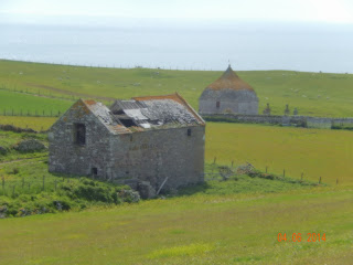
| Ruined barn and old mausoleum at Mains of Ulbster |
At last as I crested the brow of the hill the Mains of
Ulbster came into view. Just as promised by the map there was a mausoleum just
beyond it – a rather striking building. Research afterwards says that it’s the
Sinclair Mausoleum, and has a date of 1700, though was apparently built from the
stones of the earlier St Martin’s chapel. It’s probably too far from anywhere
to have become widely known, though it certainly looks as if it’s a building of
note.
After this it was about two miles along minor roads – half
the spaced out buildings derelict, others in very poor repair, and yet others
apparently new and cherished. This seems characteristic of this part of the
world. Finally I reached the point beyond the final house where I intended to
strike out on what I thought was a footpath to follow the coast.
 |
| Local farming practices (1) |
The country may be relatively dull, but there’s plenty of
bird life to keep one interested. Lots of meadow pipits, oystercatchers, lapwings,
sparrows by the farms; the occasional curlew, wheatear, songthrushes in most
un-songthrush-like places. The first cuckoo I’d heard in Scotland. At one stage
I thought I saw a merlin, but I couldn’t get the field glasses on it quickly
enough. The wildflowers are less varied and numerous than elsewhere. But there
are patches of bluebells; a fair bit of campion; dandelions; daisies; stitchwort;
buttercups; some violets and orchids on
the damper ground. The gorse is the exception – ubiquitous, intense, often in
great patches. There’s plenty of heather, too, but it’s pretty colourless at
this time of year.
 |
| It doesn't look like a bog ... |
It soon appeared that I’d made a big mistake in map-reading.
What I’d thought was a footpath wasn’t. The footpath actually started 500m or
so further on. (I could actually see where there was a path through the heather
in the distance.) But the 500 metres were impossible – or more accurately,
impassable. I managed about 150m before the ground became almost a complete
swamp, and the end came when I managed to get both boots fully under water.
Very frustrating, but I really couldn’t see any way through. So it was back to
the track, off with boots and socks, and a literal wringing of hands to get the
water out.
 |
| More local farming practices as I retrace my way |
Re-shod, it was back to the minor roads, and on in to
Thrumster, the last village on the A99 before Wick. So my well-intentioned A99
avoidance strategy came to nought. And the rest of the day’s walk was four
miles or more of the A99. A huge disappointment.
Because of my attempt to take a coastal path, it had taken
me more than an hour longer than I’d planned – and cost me an extra three miles
or so. It had been a lesson in map-reading that I must bear in mind up here in
Scotland.
 |
| Mackays Hotel on the shortest street in the world |
Eventually I arrived in the centre of Wick, where we were staying at Mackays Hotel. This is on the river, and shaped like a wedge of cheese. The end of the cheese - thew nose, I guess - is actually a street with its own name, and is (according to the Guinness Book of Records) the shortest street in the world. It's no more than ten feet or so, but I guess it counts as a street because the hotel's bistro is on it and has the official address 1 Ebenezer Place.
Bright first thing,
but increasing levels of cloud, so that it was largely overcast by the end of
the walk; rain after getting to Wick. 11 to 15C. 17.28 km, including fruitless
attempt to find coastal path; 92m of ascents and 157m of descents. A99 to start
and finish; minor roads and some cross-country walking in middle of the walk.
No comments:
Post a Comment