Early start – breakfast at 8:00; luggage collected at 9:00, and away by 10 past. The first wise decision was to cut the corner, and go cross-country to Portheras Cove rather than to go to Pendeen Watch – the lighthouse – to join the Coastal Path. The first climb was up from the Cove to the heights – a 70m ascent. Then along the Coastal Path for something like 6 miles.
 |
| Brian and Jill Rowson - ready for the SWCP |
Very rocky and wet, and slow going. The weather was cloudy, but not cold. The walk was brutal, with level bits only at high level and another four or five steep climbs from where the various small streams have cut sharp-sided valleys in the coast. Good company with Brian and Jilly Rowson, who enjoyed it thoroughly. Embarrassing at one stage to be passed by a family of four, with dogs, and who from being a quarter mile behind us at one stage were half a mile ahead when they eventually turned off the path and back up to the road. But they weren’t going as far as we were – perhaps some compensation.
Occasional other walkers too, including a couple with four dogs who overtook us with ease, and then turned back to pass us in the opposite direction.
Just before the Gurnard’s Head we saw a pair of peregrines mobbing four ravens. Wonderful to behold – great sweeping, scything passes within inches of the ravens. No contact, though – almost as if it was just to show off aerobatic skills.
 |
| The Gurnard's Head - Just like the fish? |
The worst part was after the Gurnard’s Head, where the next bay – Treen Cove – involved a steep descent and stiff climb up again. Brian and Jilly had stayed here years ago in a house owned by a friend of theirs, set up from the cove half way to the Gurnard’s Head Hotel, which is allegedly excellent but was too far for a diversion.
The most brutal bit was the final cove, where the footpath to Zennor cuts inland. Round the headland, a wonderful view of Veor and Pendour Coves, and then a long climb to pass inland of Veor Cove to reach Pendour Cove. Wet, very rough going, and the steps to climb more than 50m to the road for Zennor. Then up to Zennor itself, where we stopped at the Tinners’ Arms – just a half pint for me, but very welcome.
Brian and Jilly summoned a cab to take them back to Pendeen for their car, while I went on to St Ives. Before turning inland for Zennor there had been a signpost indicating that we had come 7 miles from Pendeen Watch (about the same from Pendeen itself, I assume), and a further 6 to St Ives. It was already after 2:00 pm, so I decided to take the field path from Zennor itself rather than continuing along the Coastal Path. We had met a local earlier who said that the last bit was particularly challenging, and I didn’t fancy the risk of getting completely exhausted and finding myself still on the path after dark.
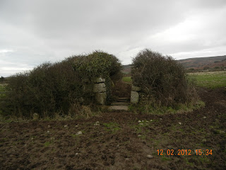
As it was the field path was a full five miles. Level for the most part, but the odd minor ascent and descent. The worst part was the mud in a couple of farmyards full of steaming cattle, which was impossible to avoid, and made by boots thoroughly caked and rather smelly. (I hate to think what they’ll have done to the rest of the stuff in the airing cupboard they’ve been left in overnight.) And there were countless stone stiles to cross. Some just half a dozen granite beams across trenches; others with steps up to cross a higher beam and steps down the other side. They seem to be uniquely Cornish.
 |
| Cornish Stile - and Cornish Mud |
St Ives took for ever to appear, and it was more than a mile through the built up area before arriving at the harbour and finding the Grey Mullet B&B. Richard Dale was there to welcome me, having come from a splendid lunch at Rick Stein’s restaurant in Padstow.
Unpacking; a shower; out for dinner. Writing this up, and an early bed. Just hoping that I’m not affected by cramp tonight. I found today very tough – nearly nine hours on the way – but astonished to find that technology tells me I walked slightly less than yesterday, and that the climbing and descending were less as well. I just hope that weariness is not cumulative!
Fine but cloudy, about 8C, but colder later. 20.48 km; 8 hrs 43 min; 551m ascent; 669m descent. It must have been more!
Map - http://www.mapmyrun.com/workout/93779550
Map - http://www.mapmyrun.com/workout/93779550
No comments:
Post a Comment